Passage Weather: Essential Tips for Safe and Efficient Sailing
Passage weather is an essential aspect of sailing and maritime travel, providing crucial information on wind speed, direction, wave height, and atmospheric pressure along a particular route or sea passage.
By accessing accurate and up-to-date forecasts, sailors and mariners can ensure safe navigation and efficient route planning. Sailing weather forecasts, wind gusts are part of a larger picture that need to be observed.
A variety of resources are available for obtaining reliable passage weather data, including information from NOAA and NWS.
These sources can offer vital details on the conditions that may be encountered during a journey, helping travelers make informed decisions about the best course to follow.
Incorporating passage weather forecasts into the planning process is crucial for optimizing safety and efficiency at sea.
As weather patterns change rapidly, having access to current and accurate information enables sailors to adapt their itineraries and navigation strategies accordingly, ensuring a smoother and safer journey.
Understanding Passage Weather
Fundamentals of Weather Systems
Passage weather is a crucial aspect of sailing, as it provides essential information for sailors to plan their journeys effectively.
Weather systems at sea are dependent on factors such as wind speed, wave height, temperature, and direction.
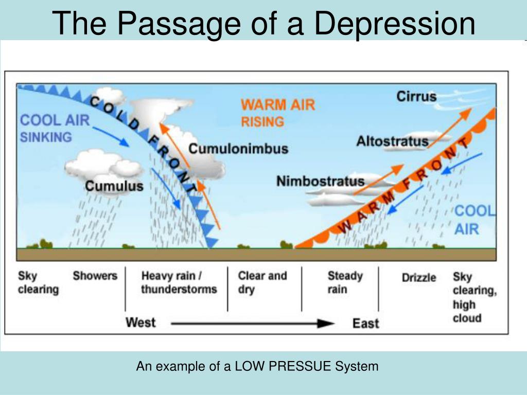
These factors come together to create high and low pressure zones, which in turn create the weather conditions associated with cold and warm fronts.
A cold front occurs when cold air pushes out warmer air, resulting in precipitation and lower temperatures. Conversely, a warm front is formed when warm air takes over a colder air mass, causing gradual precipitation and higher temperatures.
These fronts are essential components of the weather systems at sea and directly impact sailing conditions.
Importance of Wind and Wave Forecasts
Wind and wave forecasts are of critical importance when planning a sailing route, as they provide a clear indication of the anticipated weather conditions at sea.
Knowing the wind speed and direction can help sailors make informed decisions regarding their course, while higher wave height can lead to severe seas and hinder a boat's performance.
Factors affecting sailing conditions:
- Wind speed
- Wave height
- Temperature
- Wind direction
Having a comprehensive understanding of both wind and wave forecasts can contribute to a safe and successful sailing experience, while ignoring such information can pose a significant risk.
Weather Routing for Sailing
Weather routing is an essential part of sailing, as it allows sailors to plan their journey around anticipated weather conditions for a smoother and safer passage.
By doing so, one can avoid severe seas, storms, or other unfavorable situations that may arise.
When planning a route, it is essential to take into consideration the different weather forecasts available. Thunderstorms aren't always a no-go situation, knowing severity & timeline can make or break your plans.
Utilizing accurate and up-to-date information, sailors can make informed decisions about their course, ensuring that they find the most efficient and safest route available.
Passage Planning Tools
Comparing Planning Platforms
When it comes to passage planning, there are several online tools and platforms available to help sailors plan their journey and stay informed about the weather conditions.
Two popular platforms are PassageWeather and FastSeas.
Both of these tools focus on providing accurate and reliable 7-day wind, wave, and weather forecasts to aid in passage planning and weather routing.
PassageWeather offers a simple and user-friendly interface, making it easy for sailors to get the information they need quickly.
On the other hand, FastSeas is a more advanced tool that calculates the fastest route between two points based on the current NOAA GFS weather forecast and oceanic conditions.
This makes it an ideal choice for those looking for a more in-depth analysis of their journey.
In terms of accuracy, both platforms rely on the latest available account data and offer updated forecasts every 12 hours. However, as with any weather forecasting tool, it is important to keep in mind that these predictions can be subject to change and should be used as a guide, rather than an absolute guarantee.
Using Opencpn for Weather Analysis
Opencpn is another popular passage planning tool that offers more than just weather information.
It is a free and open-source chart plotting and navigation software, known for its extensive customization options and compatibility with various devices.
This makes it a versatile option for sailors who wish to incorporate weather analysis into their passage planning workflow.
One key feature of Opencpn is its ability to import GRIB files, which contain detailed weather data such as wind speed, direction, and atmospheric pressure.
This enables users to overlay weather information directly onto their navigational charts, giving them a clear visual representation of how the weather may impact their journey. This connection of information has helped us in a few voyages, after overlaying we derived a precise plan.
Aside from weather analysis, Opencpn also offers numerous other features essential for passage planning, including route planning, waypoint management, and chart management.
In addition, its extensive plugin library allows users to further expand its functionality according to their specific needs.
Assessing Data Sources
Advantages of Passageweather.com
Passageweather.com is a popular website among sailors and boaters for obtaining passage weather information. It provides:
- Comprehensive forecasts: Detailed wind and wave forecasts, along with atmospheric pressure, help users plan their sailing routes.
- Accessibility: The platform offers mobile apps for iOS and Android devices, enabling on-the-go access to weather data.
- User-friendly interface: The website is easy to navigate through a web browser and provides visually appealing forecast maps.
Exploring Other Weather Websites
There are numerous other websites available for obtaining passage weather forecasts. Some of the notable ones include:
- Weather.com: A well-known source of general weather information, also offering marine forecasts.
- NOAA.gov: The National Oceanic and Atmospheric Administration provides marine forecasts and wind data on its official website.
- SailFlow.com: A platform focused on wind forecasts, accessible through a browser or mobile app.
Accuracy and Reliability of Forecasts
Accuracy is a key consideration when assessing data sources for passage weather information.
While websites like Passageweather.com are popular, it is essential to remember that forecasts may not always be 100% accurate.
Weather models, although constantly improving, still have limitations in forecasting wind and wave conditions.
Incorporating multiple sources, such as information from NOAA or Weather.com, can help improve overall forecast reliability.
By comparing data from various sources, users can develop a more complete understanding and make better-informed decisions about their sailing plans.
Technology in Passage Weather Forecasting
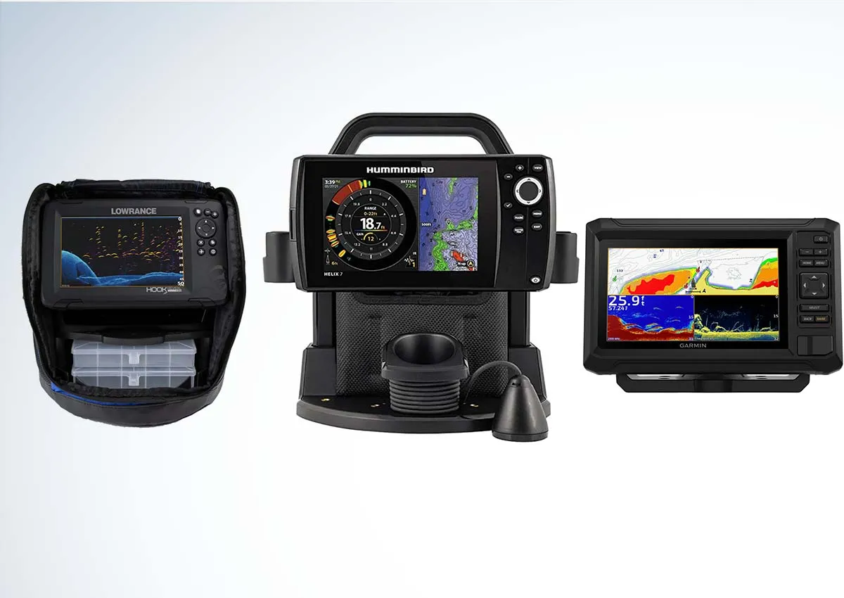
Navigational Devices and Software
The advancement of technology has significantly improved maritime navigation and, consequently, passage weather forecasting.
Various navigational devices and software are now readily available to sailors and adventurers, offering accurate and reliable data for optimal route planning.
These tools not only provide real-time insights into wind, wave, and weather patterns but also help users make informed decisions and navigate the waters safely.
Some popular navigational devices and software include:
- Chartplotters and GPS devices
- Electronic weather routing software
- Digital wind and wave forecasting tools
Additionally, many of these tools allow for customization, enabling mariners to adjust settings based on their preferences and specific sailing conditions.
Email and Data Services at Sea
Access to timely and accurate weather information is vital, especially during long offshore passages.
Fortunately, the rise of email and data services at sea has facilitated seamless communication and data sharing among sailors, meteorologists, and other stakeholders—further enhancing passage weather forecasting.
By utilizing specialized applications, sailors can:
- Receive weather updates and forecasts directly to their devices
- Send and receive texts and emails while offshore
- Access helpful websites and resources for additional information
It is crucial to choose a reliable email and data service provider to ensure a smooth flow of information and optimal communication.
Utilizing Spot Devices for Tracking
Spot devices have become increasingly popular in recent years. These portable gadgets not only contribute to the improvement of passage weather forecasting but also allow sailors to stay connected with family and friends.
Spot devices use satellite technology to track one's location and can transmit essential information, such as:
- SOS emergency signals
- Updates on position and movement
- Customizable messages to inform others about one's well-being
The integration of spot device tracking with other navigational tools enables sailors to make better-informed decisions about course adjustments, ensuring a safer and more efficient journey.
Real-world Applications
Weather Considerations in Ocean Races
Ocean races, such as regattas and long-distance sailing events, rely heavily on accurate and up-to-date passage weather forecasts.
These forecasts provide critical information about wind speed, direction, wave height, and atmospheric pressure that influences race strategies and ensures the safety of sailors.
During an ocean race, weather conditions can change rapidly, making it crucial for race organizers and participants to have access to reliable sailing weather forecasts.
- Wind Speed and Direction: Knowing the wind speed and direction helps sailors optimize their routes and sail configurations for maximum efficiency.
- Wave Height: Understanding wave height patterns enables sailors to prepare for challenging conditions or avoid hazardous areas.
- Atmospheric Pressure: Changes in atmospheric pressure provide insight into approaching weather systems, allowing sailors to prepare for storms or shifting winds.
Beta Testing and Gathering Feedback
Advancements in technology and weather forecasting models have a significant real-world impact, particularly in the field of passage weather prediction.
Conducting beta testing and gathering feedback from end-users, including sailors and researchers, is essential for improving these tools.
For instance, next-generation weather models are designed to perform efficiently in real-world scenarios. Their evaluation during actual extreme weather events is vital to refine their accuracy and effectiveness.
Developers can:
- Assess the performance of their weather models by comparing predictions with real-world observations.
- Identify areas needing improvement or additional features.
- Gather suggestions and feedback from testers with a wide range of sailing experience and prioritize updates.
The constant refinement and optimization of weather prediction tools, driven by beta testing and feedback, contribute significantly to the safety and efficiency of sailing. Incorporating the expertise of sailors and researchers, forecasts become more accurate and dependable, ultimately benefiting all individuals and vessels navigating the ocean's ever-changing conditions.
Wind Patterns and Effects
Understanding the Global Wind System
Wind is a crucial factor for passage weather as it influences the weather conditions along sea routes.
The global wind system can be primarily classified into three major categories:
- Trade Winds: These winds blow from the northeast in the Northern Hemisphere and from the southeast in the Southern Hemisphere. They are characterized by their consistent direction and strength.
- Westerlies: These winds blow from the southwest in the Northern Hemisphere and from the northwest in the Southern Hemisphere. They are responsible for the movement of weather systems across the mid-latitudes.
- Polar Easterlies: Originating from the polar regions, these winds blow from the east. They are cold and dry, contributing to the formation of polar highs.
In addition to these major wind systems, local wind patterns can also have a significant impact on the weather conditions during a sea passage.
Effects of Local Winds
Local winds are influenced by the Earth's surface features, such as mountains, valleys, and large bodies of water like oceans.
Some examples of local winds include:
- Sea Breeze: A wind blowing from the sea towards the land, usually during the day due to the temperature difference between the land and the sea.
- Land Breeze: A wind blowing from the land towards the sea, typically during the night when the land cools faster than the sea.
- Valley Breeze: A wind blowing uphill along the sides of a valley as the air at higher elevations heats and rises.
- Mountain Breeze: A wind blowing downhill as the air at higher elevations cools and descends during the night.
Understanding the complex interplay of various wind systems and their effects on the ocean currents is vital for predicting passage weather conditions.
The global wind system interacts with local winds, creating variable weather conditions at different points along a sea route. Skilled sailors must be aware of these wind patterns to ensure safe navigation and efficient route planning throughout their journey.
Tips for Sailors
Preparation for Different Sea Conditions
To ensure a safe and comfortable journey, sailors must be prepared for various sea conditions.
Understanding weather patterns and forecasting is an essential skill for any sailor. Familiarizing oneself with the different tools and resources available, such as Passage Weather and FastSeas, will allow for better planning and decision-making.
Know your route:
It's important to study the route, possible alternatives, and the typical weather patterns for the area. This understanding will enable you to plan your passage better, identifying the most suitable times and locations to take advantage of favorable weather.
Gear and equipment:
Ensure that your sailing gear and the boat's equipment are appropriately suited for the range of conditions expected during your passage.
Make a checklist for essential items like lifejackets, navigation instruments, communication devices, and safety equipment.
Experience and training:
Continuous learning and enhancement of sailing skills are vital for sailors. Enroll in relevant courses that provide practical training in weather forecasting, navigation, and emergency situations.
Effective Use of Passage Weather Information
Passage weather information should be utilized to make informed decisions. Here are some key points on effectively using passage weather data:
- Stay Updated:
- Tailor forecasts to your needs:
- Combine with other resources:
- Backup forecasts:
Frequently Asked Questions
What is the best source to consult for marine weather forecasts before sailing?
One of the most reliable sources for marine weather forecasts is PassageWeather. It provides comprehensive data, surface wind forecasts, and surface pressure forecasts from the European Centre for Medium-Range Weather Forecasts (ECMWF) and NOAA/NCEP.
How does the passage weather in the South China Sea differ between seasons?
In the South China Sea, the weather differs between the monsoon seasons.
The Northeast Monsoon occurs from November to March, with the wind direction predominantly from the northeast, while Southwest Monsoon occurs from June to September, with winds coming from the southwest.
The transitional months between these monsoon seasons, April-May and October-November, are characterized by variable winds and weather conditions.
What are some safety tips for navigating the Atlantic during adverse weather conditions?
When sailing in the Atlantic, it's crucial to monitor weather forecasts carefully, especially during hurricane season.
In adverse weather conditions, reduce sail area, secure all hatches and ports, and ensure safety equipment is in working order.
Extra caution should be taken when navigating near weather systems such as cold fronts, warm fronts, and low-pressure areas.
Which factors should be considered when planning a voyage through the Indian Ocean?
Sailors should consider the following factors when planning a voyage in the Indian Ocean: the timing of the seasonal monsoons, the Intertropical Convergence Zone (ITCZ), and impacts of tropical cyclones.
Careful route planning, understanding local weather patterns, and monitoring real-time weather data are essential for safety and efficiency.
What is the typical weather pattern for the Mediterranean for those planning a passage?
During the warm months from late spring to early autumn, sailors in the Mediterranean can expect settled weather. Sea breeze patterns develop during the day and subside at night.
Winter months bring more unsettled weather conditions, including stronger winds and the possibility of heavy rain and storms. Monitoring forecasts and understanding the local microclimates can help sailors plan their passages effectively.
How can sailors interpret weather charts effectively to ensure a safe passage?
To interpret weather charts effectively, sailors should consider the following elements: wind direction and strength, wave height and direction, and surface pressure features such as high and low-pressure systems.
Developing a good understanding of these elements, in conjunction with real-time forecasts and updates, can help sailors to make informed decisions during their passages.

Charlie is Editor-in-Chief of Sea Magazine